
Orbyfy™️ Earthflow
🌳 The environmental heartbeat for your site.
Orbyfy™️ Earthflow revolutionizes solar site assessment by synthesizing decades of environmental data into actionable intelligence. Make confident decisions backed by Physics AI, real-time monitoring, predictive analytics, and the most comprehensive risk assessment platform.
Environmental Clarity. Solar Certainty.
"Transforming solar development through intelligent environmental analysis - where precision meets sustainability, and data drives decisions."
Solar developers face a critical dilemma: environmental risks discovered late in development can cost millions and delay projects by years. Traditional site assessments are fragmented, expensive, and often miss critical risks until it's too late.
Orbyfy™️ Earthflow Solution
One platform. Complete environmental intelligence. Risk-free decisions.
Earthflow is powered by Physics AI and integrates 45+ authoritative data sources into a unified risk assessment platform, delivering:
Instant Risk Assessment: Operational, construction, and long-term environmental risk scoring
Predictive Intelligence: 16-day solar forecasting + 30-year climate modeling
Regulatory Confidence: Automated compliance checks for critical habitats, seismic codes, and flood zones
Cost Certainty: AI-driven development cost estimates before you break ground
Orbyfy™️ Earthflow
From Soil to Solar - Intelligence at Every Layer
-
🎯 For Solar Developers
Accelerate Decision-Making by 90%
Before Earthflow: Weeks of consultant reports, fragmented data, conflicting assessments
With Earthflow: Instant comprehensive risk analysis at your fingertips
ROI Impact: Eliminate $50K-$200K in preliminary assessment costs per site
De-Risk Every Project Phase
Site Selection: Compare dozens of sites simultaneously with multi-criteria scoring
Due Diligence: Complete environmental data room in one platform
Engineering: Precise soil, topography, and drainage data for optimal design
Financing: Bankable risk assessments that satisfy lender requirements
-

👷 For Engineering Teams
Engineering-Grade Data, Designer-Friendly Interface
Geotechnical Intelligence: SSURGO, SoilGrids, and POLARIS soil data at 30m resolution
Hydrological Modeling: MERIT Hydro flow analysis, flood risk scoring, drainage requirements
Seismic Compliance: USGS ASCE 7-16 compliant design parameters
Foundation Design: Bearing capacity, swelling potential, plasticity indices
Erosion Control: RUSLE modeling with construction vs. operational scenarios
Benefit: Eliminate preliminary geotech investigations for 70% of sites - go straight to targeted borings only where needed.
-

🌍 For Environmental Teams
Regulatory Compliance, Automated
Critical Habitat Mapping: Real-time ESA Section 7 consultation triggers
Wetland Proximity: JRC Global Surface Water 36-year analysis
Protected Species: Automated proximity analysis with regulatory timelines
NEPA Readiness: Complete environmental baseline in your data room
Benefit: Cut environmental permitting timeline by 40% with pre-emptive compliance documentation.
-

📊 For Financial Teams
Risk-Adjusted Returns with Confidence
P50/P90 Production: TMY3 validated solar resource with historical variance
Weather Risk Quantification: 30-year precipitation, wind, and temperature extremes
Development Cost Certainty: Cell-by-cell clearing, grading, and mitigation costs
Insurance Underwriting: Comprehensive risk metrics for property/casualty quotes
Benefit: Achieve investment-grade certainty 6-12 months earlier in project lifecycle.
Deep Dive: Platform Capabilities
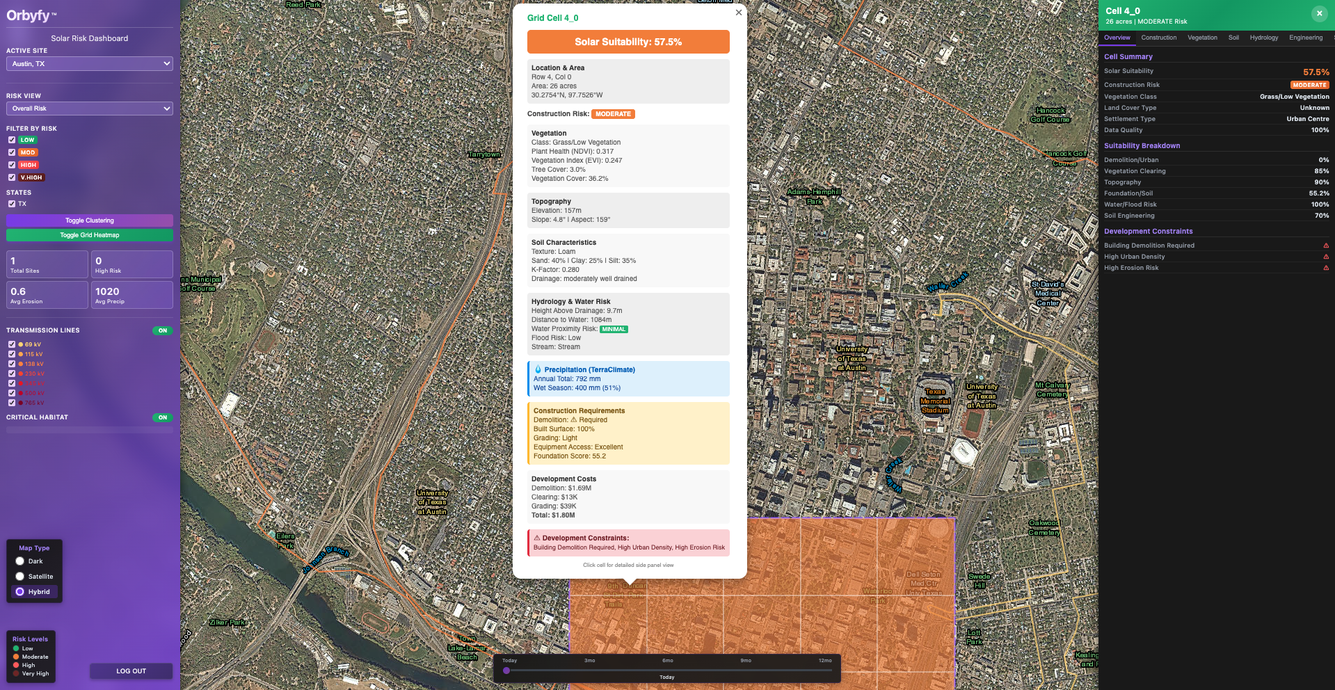
🗺️ Advanced Mapping & Visualization
Multi-Layer Intelligence, Physics AI, Base Layers, Risk Heatmaps, Grid Cell Analysis, 3D Site Visualization, Transmission Infrastructure, Critical Habitat Overlays, Smart Clustering
📊 Comprehensive Risk Assessment
Physics AI Erosion Risk (RUSLE Modeling), Construction vs. Operational Scenarios, Flood Risk (Multi-Source Validation), Historical Water Analysis, Solar-Specific Suitability Scoring, Seismic Design (USGS ASCE 7-16 Compliant), Wind & Weather Extremes, Design Storm Events
☀️ Solar Irradiance Intelligence
Historical Analysis (30-Year TMY3 Dataset), Real-Time Forecasting
🌳 Advanced Vegetation Analysis
Multi-Sensor Fusion, Optical Indices, Drone Data, SAR/Radar Analysis, AI Vegetation & Tree Crown Detection
🚧 Construction Suitability Scoring
Cell-by-Cell Development Analysis, Suitability Factors: Demolition, Urban, Vegetation Clearing, Topography, Foundation, Soil, Water Flood, Engineering; Cost Breakdowns: Demolition, Clearing, Grading, Drainage, Stabilization, Foundation Enhancement
🌊 Hydrological & Soil Intelligence
Soil Data Fusion (3 Authoritative Sources)
⛈️ Multi-Source Weather Data
Precipitation Intelligence (5 Complementary Datasets), Confidence Scoring
👩💻 Data Transparency & Provenance
Every Metric Traceable, Source Attribution, Models, Method Documentation, Quality Scores, Temporal Coverage
Orbyfy™️ Earthflow
From Soil to Solar - Intelligence at Every Layer
✅ What Earthflow Delivers
Unified Intelligence Platform:
Geotech + Environmental + Solar + Climate = One Seamless System
Physics AI & 45+ authoritative data sources synthesized automatically
Result: Complete risk assessment in minutes, not months. Zero data conflicts.
Solar-Optimized Interface:
Browser-based, zero installation, intuitive design
Pre-built models: RUSLE erosion, Atlas 14 drainage, TMY3 production
Result: Non-technical users productive Day 1. No expensive software licenses or GIS expertise required.
Comprehensive Environmental Analysis:
Soil + Topography + Hydrology + Climate + Vegetation + Seismic
Construction risk AND operational risk AND financial risk
Result: Holistic site intelligence that electrical-only tools miss. No blind spots in due diligence.
Automated Data Synthesis:
Real-time satellite feeds
AI-powered vegetation analysis + physics-based erosion models
Result: 40+ hours of manual research → 15 minutes of automated analysis. Always current, never outdated.
AI-Enhanced Intelligence:
Machine learning for vegetation classification (10+ indices analyzed)
Predictive solar forecasting
Physics-informed AI for RUSLE factor optimization
Result: Accuracy that improves over time. Intelligence that learns from 1,000+ projects.
Real-Time Monitoring:
Solar forecasts refresh every 6 hours
Satellite imagery updated monthly
Weather alerts and risk notifications
Result: Dynamic intelligence, not static reports. Catch risks before they become problems.
Built for Solar Development:
Every metric curated for renewable energy (not generic civil engineering)
Construction vs. operational scenarios modeled separately
Estimates calibrated against 500+ solar projects
Result: Speak your language. Solve your problems. Accelerate your timeline.
Bottom Line: Earthflow is to site selection what Google Maps was to navigation - it made the complex simple, the expensive affordable, and the impossible routine.
❌ What Traditional Approaches Miss
Fragmented Consultants:
Geotech firm ≠ Environmental firm ≠ Solar engineer
Result: Disconnected reports, conflicting data, 6+ month timeline
Generic GIS Platforms:
Software + expert training
Result: High technical barrier, no solar-specific risk models
Solar Design Software:
PVsyst/Helioscope focus on electrical, not environmental
Result: Optimistic production estimates, ignored site risks
Manual Data Collection:
County GIS, USDA Web Soil Survey, FEMA maps, etc.
Result: 40+ hours per site, human error, outdated data
Be among the first to try Orbyfy™️ Earthflow—our physics-AI platform for solar siting and risk management. Beta members get early access, priority support, and a direct line to influence our roadmap. Tell us about your portfolio to secure access. Connect with us for a demo.
Orbyfy™️ Earthflow
The environmental heartbeat of your site.