
Orbyfy Physics-AI Digital Twins™️
City-scale climate digital twins powered by Physics AI.
Climate risks into climate forces and impacts and damages for buildings, infrastructures and homes.
Physics-AI is not ‘black-box AI’.
Orbyfy’s Approach: From Climate Risks → Climate Forces → Physical Impacts
At Orbyfy, our city-scale digital twin platform is powered by Physics AI—also known as First-Principles AI—so you get rigorously constrained, explainable simulations rather than opaque, “garbage in, garbage out” predictions.
What Is ‘Black-Box AI’?
Data-Driven Only: Learns patterns purely from historic data, without respect for underlying physical laws.
Limited Explainability: Offers little insight into why a model makes a given prediction.
Risk of Unrealistic Results: Can produce physically impossible scenarios when faced with extremes or data gaps.
What Is Physics AI?
First-Principles Foundation: Neural networks are explicitly constrained by the partial differential equations (PDEs) governing fluid mechanics, structural dynamics, heat transport, and more.
True Explainability: Every output is backed by the same physics that shape the real world —whether determining flood inundation depths due to river-based floods or wind pressures on buildings from hurricanes.
Robust Under Extremes: By embedding advection–diffusion–reaction and shallow-water equations directly into the learning process, Physics AI resists “model drift” and remains accurate even under rare, high-impact events.
Why Physics AI Matters for Climate Digital Twins
Trustworthy Simulations
No hidden shortcuts: our models simulate water flow, wind loads, and heat transfer exactly as nature dictates.
Actionable Insights
Explainable risk metrics let engineers, insurers, and city planners understand how and why assets are vulnerable—without needing a PhD in numerical methods, simulation or computational fluid dynamics.
Versatile Use Cases
Hurricane and wind impact simulations
Flooding and hydrodynamic simulations
Hail and impingement simulations
Fire and thermodynamic effect simulations
Drought simulations
Earthquake and vibrational impacts simulations
Erosion and coastal effects simulation
Orbyfy Physics-AI Digital Twins™️
Introducing Orbyfy Physics-AI
Digital Twins™️
City-Scale Digital Twins for Climate Risk Modeling
We are Google Earth meets Risk Analytics.
We translate climate risks into climate forces into impacts & damages for buildings, infrastructure and homes.
We do this via city-scale climate digital twins to quantify the physical impact of climate perils on built environments. Our secret sauce is GPU-optimized Multi-Physics-AI.
Climate Perils: Models for hurricanes, flooding, wildfire, hail, drought & erosion.
Customizable Areas of Investigation: Including cities, postal codes & specific latitudes/longitudes.
Scenario Analysis: Covers "1-in-100 year" events, outliers & stochastic modeling.
3D Models & Meshes: Integrates topography, buildings & vegetation.
Damage Categories: Assesses damage with risk scorecards & ASCE building codes.
Climate KPIs: Provides insights like probabilities of default, loss estimates & portfolio climate VaR.
Risk Visualization: With a modular risk engine, dashboards & automated reporting.
Orbyfy Physics-AI Digital Twins™️
Geolocate risks. As easy as searching for an address on Google Maps.
Multi-physics AI engine powering climate risk analytics.

Our use cases
-
Hurricane & Wind-Related Damages
Damages & impacts from Category 4 hurricane.
HOUSTON, TEXAS
-
River & Surface-Based Flood Risk
River and surface-based flood risk & near-real-time flood risk.
BRITISH COLUMBIA, CANADA
-
Wildfire Risk & Data Integration
Wildfire intensity, propogation, & high intensity spark.
NORTHERN CALIFORNIA, USA
-
3D City-Scale Digital Twins
3D city-scale digital twin under hurricane wind loads.

-
3D Dynamic City-Scale Digital Twins
3D city-scale digital twin river-based flooding.

-
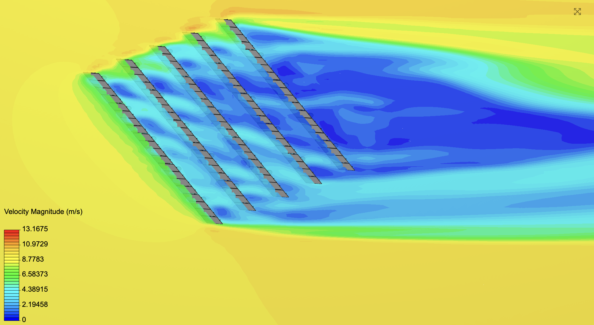
Solar Farm Hail Damages
Solar panel installation climate impacts.
Our industries
-

Power Utilities
Climate risks to impacts on power grid infrastructure.
-

Banks & Insurers
Climate risks to impacts on mortgage, asset, and loan portfolios.
-

Real Estate Portfolios
Climate risks to impacts on buildings and campuses.
What are you waiting for?
Start now. Begin a pilot today. Start with a target list of addresses, buildings, infrastructures or homes under evaluation.
Request a Demo → Experience real‐time wildfire forecasts and risk maps with Orbyfy Ignite™️ & explore different flood scenarios for 1-in-10, 1-in-20, 1-in-50, and 1-in-100 year storm events with Orbyfy Aqualyt™️.
Integrate via API & Outputs → Seamlessly ingest risk scores into your GIS, underwriting, or asset-management systems.
Partner with Orbyfy → Co-develop climate digital twin algorithms.